Welcome! 欢迎! 歡迎! ¡Bienvenido!
The Fenway Transportation Action Plan, a joint effort between the Planning Department and the Boston Transportation Department (BTD), will guide changes to Fenway streets and the public realm.
Our work will include collaborative planning, analysis, and design and will be aligned with three broad goals:
- Expand Fenway walking, biking, and transit networks that are safe, comfortable, and connected;
- Ensure Fenway remains a welcoming urban neighborhood for all people; and
- Ensure Fenway is resilient to a changing climate.
Our work will strive to understand the benefits and burdens across people, travel modes, and the streets and spaces that connect us all. That’s why we’re creating an equity framework to guide and inform all aspects of the Action Plan, including how we engage with you. We look forward to sharing this framework soon.
How Can I Get Involved?
Your insights will help us make the Action Plan a success. Our goal is to remove barriers to participation and receive targeted feedback from diverse perspectives, including community members, organizations, and institutions.
Thank you for attending our summer and fall “Chat with a Planner” events and taking our brief online survey! At these events planning staff distributed project information and were available to answer questions relating to the Action Plan. Our survey asked how you get around, what are your priorities for Fenway, and what does an equitable planning process mean to you.
We’ll be back with new information and ways to learn from you later this fall and winter. Please stay tuned and sign up for Action Plan updates.
Who is Involved?
The Planning Department is managing the Action Plan in close collaboration with BTD. Our City Team, which also includes the Public Works Department, Disabilities Commission, Parks & Recreation Department, and other City departments, guides all aspects of the Action Plan.
We work with an Interagency Team, which includes the Massachusetts Bay Transportation Authority (MBTA), Massachusetts Department of Conservation & Recreation (DCR), and Massachusetts Department of Transportation (MassDOT).
Why Act Now?
The Fenway neighborhood has grown dramatically. More than 10 million square feet of development in the area is under review, permitted, or under construction. City and State transportation guidelines, policies, and plans have evolved since the 2009 Fenway-Longwood-Kenmore Transportation and Pedestrian Action Plan. New growth means new trips, but new tools are available to manage those trips and achieve City goals.
What is an Action Plan?
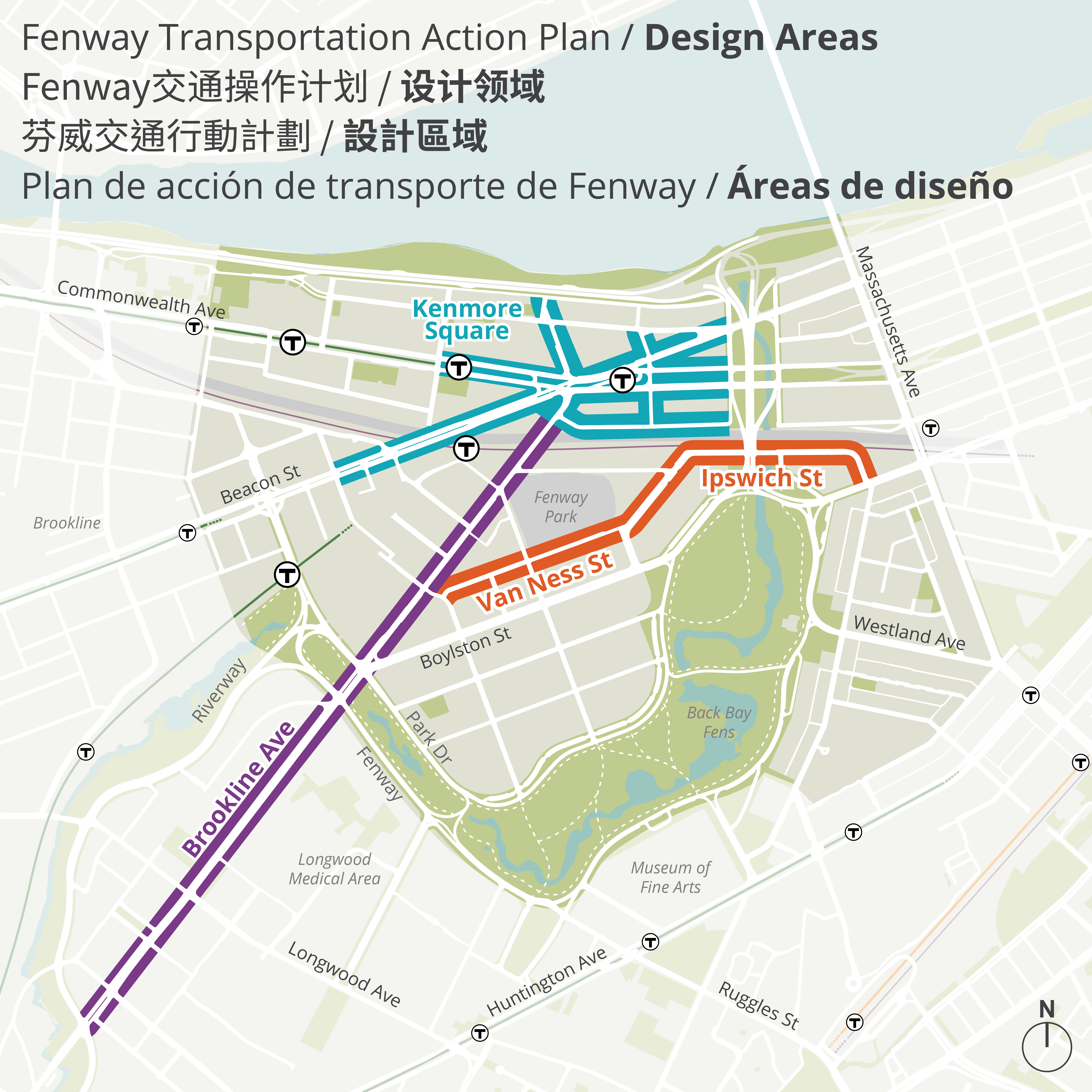
The Action Plan will identify and advance projects for implementation, not ideas to sit on a shelf. We will prepare preferred redesign concepts for Kenmore Square, Brookline Avenue, and Van Ness Street / Ipswich Street. Final design and implementation will occur in a follow-up process.
We can’t design until we first understand how these streets and places are used today and how that may change in the future. That’s why the Action Plan is starting with the planning and analysis of a broader “study area” to define a street network vision, understand growth, and test potential changes.
How Long Will the Action Plan Take?
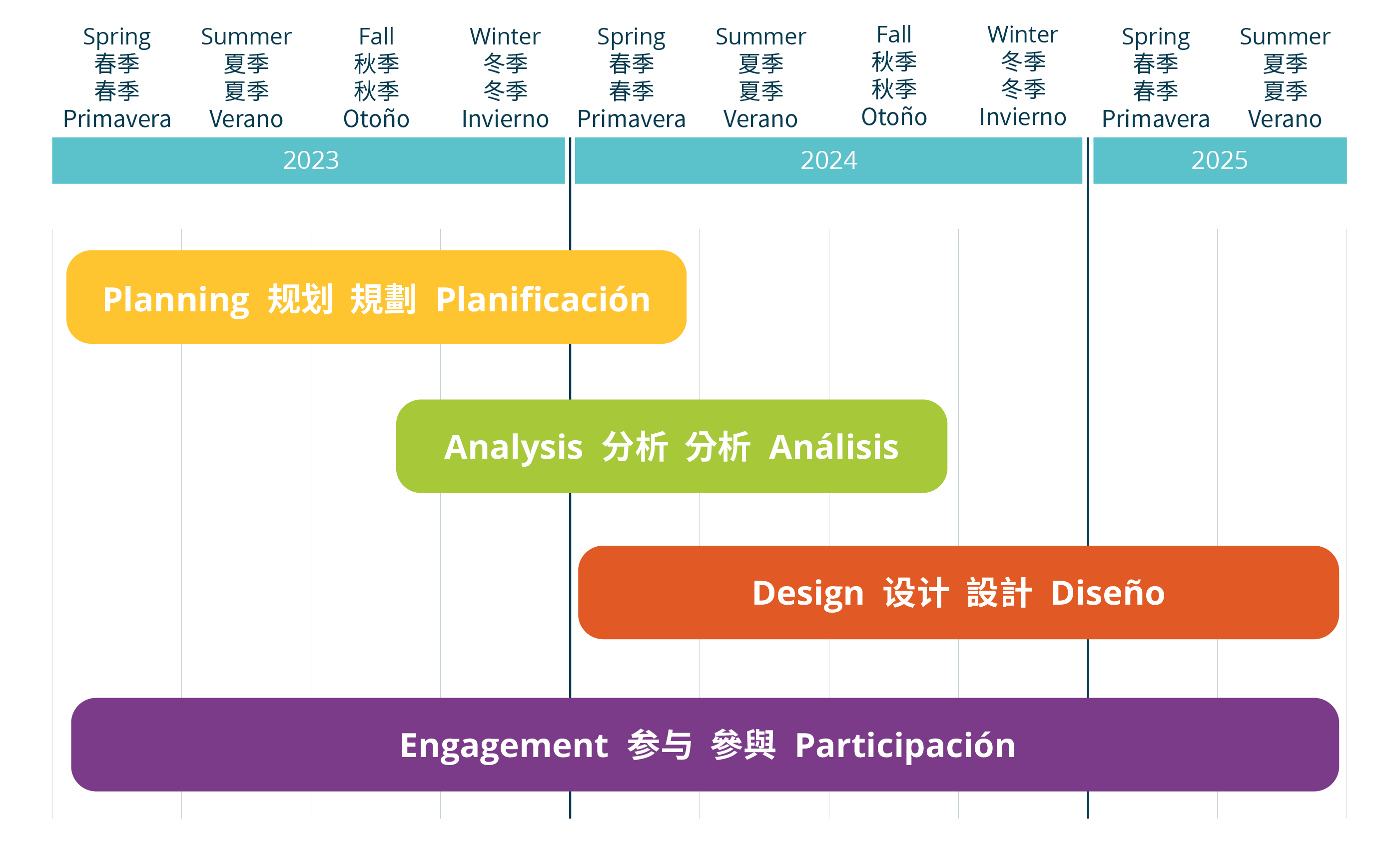
Our work began in 2023. We anticipate planning and analysis to continue into 2024, with street design also starting in 2024. Equity-focused engagement will continue throughout all tasks.
What Informs the Action Plan?
The City completed the 2009 Fenway-Longwood-Kenmore Transportation and Pedestrian Action Plan 14 years ago. Since then, how the City approaches transportation planning and design has evolved: